They are Working on Introducing Geofencing in Smart Cities. This is how they will keep you Within your 15-Minute Radius, this is why they needed us to Transition to EVs!
This is how Sweden describes geofencing: “Geofencing is a virtual fence that controls vehicles’ movements within a geographical area. By restricting vehicles from moving outside specific areas and control the speed limit.”
To read about more sinister ways geofencing tracks and monitors your every movement: “Geofencing system can easily track elderly people & kids that might be wearing GPS bracelets. Parents, guardians or family members can create a geofence around a child, elderly person or a pet so whenever they move out of the designated area the system generates an alert.”
They want us living in open air prisons!
![]()
Queensland’s Sunshine Coast has invested in the latest in data networking technology, making it the ideal location for testing and trialling new technologies and next generation digital services.
The digital services and new technologies of tomorrow will demand the kind of bandwidth, low latency and accuracy that is beyond the capabilities of many data networks.
The new Maroochydore City Centre in the heart of the Sunshine Coast was designed with next gen digital connectivity at its core. The city-wide deployment of cutting-edge digital infrastructure makes this regional tech hub the perfect location for testing next gen technology.
This infrastructure presents a glimpse into the future of smart city environments around the world and provides a unique urban testbed environment for new digital services.
Cutting-edge digital infrastructure
Thriving tech ecosystem
Low latency connectivity
Lifestyle advantages
Elevate your tech game
Cutting-edge digital infrastructure for tech testing

The Sunshine Coast has invested heavily in its digital infrastructure. The master-planned CBD is a smart city, equipped with the latest data networking technology including Wi-Fi 6 and a city-wide deployment of fibre broadband, with LoRaWAN wireless network access points and pole infrastructure.
The CBD is home to the Sunshine Coast International Broadband Network (SCIBN) cable landing station which houses the connection point for the SCIBN with landside communication networks, offering unparalleled options for low latency connectivity to Asia and North America.
NEXTDC SC1 is a Tier 3N+1 cutting-edge data centre and provides the perfect hub to connect with major networks and digital service providers offering unrivalled data capacity and lightning-fast speed via the SCIBN.
This infrastructure makes the Sunshine Coast CBD an ideal location for tech companies to test and trial their new technologies including AI automation testing, artificial intelligence software testing, augmented reality development and Internet of Things penetration testing.
Facilitating the uptake of AR and VR technologies

Data shows that the augmented reality (AR) and virtual reality (VR) markets in Australia and Oceania will experience an annual growth rate of 13.54% by 2028. The number of global users in this market segment is expected to reach 56.6 million in the same timeframe.
These services are using high definition audio and video streams and location-based services to revolutionise industries and consumer behaviour. Higher GPS accuracy, quicker asset ID, faster fault resolution and risk mitigation create meaningful new business opportunities and consumer experiences.
For example, as an alternative to intensive training, staff in utilities infrastructure maintenance can use augmented reality and smart glasses to overlay information into a technician’s field of vision. The combination of image recognition technology with high speed, low latency bandwidth available in the Maroochydore CBD enables the development of precise augmented reality services that present detailed information to the field technician. Alternatively, smart glasses can relay what they are seeing to a remote location where it can be viewed by a more experienced technician.
LoRaWAN IoT network

Maroochydore City Centre’s LoRaWAN network provides low power data network connectivity that covers almost 100% of the development area. This network is ideal for the iot pentesting and deployment of internet-of-things applications such as sensors, security, wearable technology and other devices.
The combination of Wi-Fi 6 and LoRaWAN networks offers a unique opportunity to collect vehicle telemetry data at different levels of detail. With real-time access to this data, network
managers can create a full digital twin of an entire urban environment.
The ability to model the network with high accuracy in software creates the opportunity to safely test different scenarios based on real world data for transport management and other sectors that rely on real-time asset tracking.
If a company does not want to be limited by the current Wi-Fi6 and Sunshine Coast Council active network infrastructure, there is spare fibre infrastructure to every smart light pole within the City Centre and every commercial building.
Real-world testing for a range of industry sectors

Quality of life and cost-effectiveness

Let’s not forget the lifestyle advantages. The Sunshine Coast was recently recognised as a UNESCO Biosphere and offers a high quality of life with its beautiful beaches, ancient rainforests, world-class food and agribusiness industry and thriving cultural scene.
But this idyllic location offers more than just stunning beaches and a laid-back lifestyle; it’s one of Australia’s fastest-growing tech hubs. Companies setting up shop here will find it easier to attract top tech talent who are drawn to the lifestyle as much as the work itself.
The Sunshine Coast offers a cost-effective alternative to the capital cities without compromising the quality of resources or infrastructure. Lower costs for office space, utilities and even talent can translate into significant savings, allowing companies to allocate funds to R&D and other critical areas.
Geofencing is a virtual fence that controls vehicles’ movements within a geographical area. By restricting vehicles from moving outside specific areas, such as day-care facilities and schools, and control the speed limit, a safer city is created.

In 2017, the Swedish government started a project to create safer and more sustainable cities with the help of geofencing. The project has resulted in a joint action plan developed by the Swedish Transport Administration, City of Stockholm, City of Gothenburg, Scania, Veoneer, Volvo Cars, and Volvo Group.
With this innovative technology, Sweden is leading the way in creating cities that are safer and with lower air pollution and noise levels. The measures in the geofencing action plan contribute to improved accessibility through a calmer and more consistent pace of traffic.
The key points of the action plan are to:
- Establish a research and innovation program
- Promote legislation and regulations, which support the implementation of geofencing
- Develop organisational and digital processes and data for geofencing zones
- Develop systems, routines, and processes for self-regulating systems and control of smart zones
- Investigate socio-economic and commercial potential
- Promote national and international harmonisation
- Encourage and drive demonstration and pilot projects
How Geofencing Technology Is Helping In Smart City Developments
Every object on the surface of the Earth has a location. Geofencing technologies associate different attributes to the specific object and its location along with collecting data for the objects on the city map and enabling municipalities to make better or data-driven decisions. When it comes to urban planning and smart city developments, the role of Geofencing or geospatial technologies is quite significant. The majority of the smart city solutions or developments are based on geolocation data and technologies like IoT and AI only meet the expected outcomes if they operate in synchronization with the geolocation tech.
So how does Geofencing technology empower smart city developments? Before proceeding to the use cases let’s see how the cities are using the Geofencing technologies to become smarter.
Value of Geofencing for Smart Cities
Crime prevention, event management, real estate development, city marketing, optimizing energy use, traffic and transport management are some of the Geofencing implementations in smart cities. These innovations are positively impacting the lives of the citizen.
In smart cities, drones, autonomous vehicles and smart sensors all use location-based technologies to collect and manage the location data about the object. Moreover, indoor positioning systems (IPS) and digital twin technology are also enabled by location tech.
The combination of smart city analytics and city demographics with Geofencing technologies can help the city authorities and local businesses to accurately target their initiatives and plan as per the needs of the urban community. Geofencing is also helping in crime prevention and traffic flow management etc.
The above discussion indicates that Geofencing technologies hold the potential to completely empower the smart city developments, as without the location data, the municipalities can neither enhance the services they provide nor make the cities smarter.
Now let’s discuss some use cases of Geofencing technologies for smart city developments.
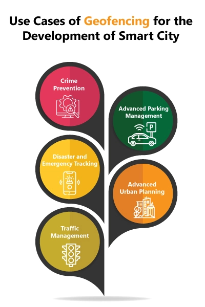
Use Cases of Geofencing for the Development of Smart City
1. Crime Prevention
The crime rate in the cities is increasing day by day, however, this problem can be catered easily with the help of technology. In different aspects, Geofencing technologies can be utilized for crime prevention. For instance, a geotagging feature of social media can be used to collect a plethora of data. The law enforcement authorities or police can use real-time social media location in order to track the use of keywords such as “fight”, “gun” and “shoot” etc. in a specific location. This helps the authorities to highlight the potential crime sites in the city and take appropriate actions. Another application of Geofencing in this regard is asset tracking. Geofence can be created around an asset such as a vehicle to monitor its location. Whenever the asset goes beyond Geofence then the associated system may generate an alert. This can prevent vehicle theft in the cities. Similar technology can be used to track the suspect who might run away after committing a crime.
2. Advanced Parking Management
The congestion on the roads of the big cities is continuously increasing and one of the main reasons behind it is vehicles cruising in search of a parking spot. In densely populated urban areas, the search for parking has become extremely challenging. However, this problem can be resolved by combining the IoT sensors with the Geofencing technology. Smart parking solutions or location services can extract the information about the available parking spot in nearby parking lots for the drivers. The system used in this regard superimposes the parking spots on the GIS mapping which ultimately gives the driver access to get real-time updates about parking spots and navigate their vehicles accordingly instead of driving around the roads in search of parking. This solution of advanced parking management helps in reducing traffic congestion on smart city routes. The systems like ParkSmart are also facilitating advanced parking management in big cities.
3. Disaster and Emergency Tracking
Cities encounter a lot of emergencies all the time and require immediate action. Advanced Geofencing intelligence anticipated by the 5G holds the potential to instantly respond to the emergencies taking place in a smart city. A location tracking system used by the authorities can immediately send automatic alerts whenever any unusual or potentially dangerous activity is tracked in the city. This helps the authorities to prepare and dispatch the emergency teams immediately. The same technology can be used to cater the emergency healthcare issues. For instance, the IoT wearable device can monitor the biomedical parameters of a person and can immediately alert the emergency services if the person is unwell or had an accident by transferring the real-time location of the person to the concerned authorities.
4. Advanced Urban Planning
Urban planning is the most important aspect of smart city development. The use of Geofencing technologies in smart cities is not limited to only providing geospatial data as this technology can also help the municipalities in creating future city layouts. GPS also has an important role to play in architectural development and making cities smarter. Geofencing and access to important location data and patterns can help engineers in designing residential areas and digital infrastructure models that will foster the more efficient use of city resources and infrastructure. Hence, with the help of geospatial technologies, the future cities will be developed as per thorough planning, unlike the modelling of current cities which is exposed to chaotic construction.
5. Traffic Management
Geofencing can also help in managing the traffic in smart cities. For instance, by using virtual parameters for an actual geographical location, Geofencing can help in applying digital traffic regulation to a particular area. By defining the geographical areas and associating rules to certain zones, Geofencing can also ensure that the autonomous vehicles are using the powertrain correctly, that too in the appropriate time and place as well as keeping the vehicles to the defined speed. By applying the Geofencing technique cities can ensure better traffic flow, create green zones, lower air and noise pollution, but most importantly, reduce traffic on the roads and make the public spaces safer to use.
6. People’s Safety
The developments in smart cities equate to public safety and security. In this regard, Geofencing technology is playing an important role in ensuring public safety. For instance, a smart Geofencing system can easily track elderly people and kids that might be wearing GPS bracelets. Parents, guardians or family members can create a geofence around a child, elderly person or a pet so whenever they move out of the designated area the system generates an alert. A similar system can easily be integrated with the citywide database and can help the communities in finding missing members. The families are also alerted immediately which ultimately increases the sense of security in the cities.
Conclusion
Smart city developments are more likely to increase in the upcoming years as the municipalities are focusing on making cities smart, secure and sustainable for the public to a greater extent. However, without using Geofencing technologies, the aims of the smart city developments cannot be achieved. This is because this technology is fueling the ways in which the location data can be used to make data-driven smart city decisions. From enabling parking solutions to securing the public, all innovative aspects can be achieved by using Geofencing technologies.
Resources:
https://t.me/LauraAbolichannel/54785
https://invest.sunshinecoast.qld.gov.au/testing-tech-in-paradise-queenslands-sunshine-coast/
https://smartcitysweden.com/focus-areas/mobility/geofencing/
https://www.conurets.com/how-geofencing-technology-is-helping-in-smart-city-developments/